


Contact Info
- Phone:
- 505-786-7014
Basics
- Type:
- National Park
Basic Directions
- From the north
- Leave US 550 at CR 7900 (which is about 3 miles southeast of Nageezi).
- Follow CR 7900 for 21 miles (8 miles paved, 13 dirt) until you reach the park.
From the south
You can reach Chaco via Highway 9 via two routes, but they are both very rough roads. Call ahead for conditions.
- Via Highway 57 / Highway 14
- Take the turnoff from Highway 9, about 13 miles east of Highway 371. The turnoff is at the former Seven Lakes Trading Post.
- Continue for 20 miles. The road will be rough dirt.
- Via Pueblo Pintado
- When you reach the community of Pueblo Pintado, take a north on Navajo 46 and remain on this rough dirt road for 10 miles.
- Take a left on County Road 7900 and remain on it for 7 miles (also partially rough dirt).
- Take a left on County Road 7950 and follow the signs for the park. You'll drive about 16 miles to the park entrance (3 miles paved, 13 rough and unpaved).
Description
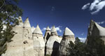
This National Historic Park preserves part of the homelands of the Pueblo, the Hopi and the Navajo Indians of the Southwest. Many, many years ago, between AD 850 and 1250, this was a hub of ancient Puebloan culture. Much of the old architecture remains, from the grand bowls of the great kivas to the humbler structures of the villages.
Start at the visitor center. The park is largely a self-guided experience and you might want to pick up a trail guide. Once you're a bit further into the park, you'll be following the Canyon Loop Drive. This nine-mile road will take you from site to site, within a short hiking distance of each.
The six sites are Una Vida, Hungo Pavi, Pueblo Bonito, Chetro Ketl, Pueblo del Arroyo and Casa Rinconada. That first, Una Vida, is a 1 mile hike (round trip). Watch for petroglyphs as you approach this ancient building. Hungo Pavi, the next, is a 1/4 mile (round trip) hike, and it's immense. This is a Chacoan great house and encloses a plaza and a great kiva, as well as 150 rooms. Third is Chetro Ketl, a 1/2 mile hike, which is the second largest of the Chacoan great houses.
Fourth is the Pueblo Bonito and the absolute "must-see" for anyone visiting the National Historic Park. A 0.6 mile hike (round-trip) takes you to this crown attraction of Chaco Canyon - which once served as the core of the canyon's Puebloan civilization. Fifth is Casa Rinconada and the small villages beside. It is a 1/2 mile hike, round trip. Last is the Pueblo del Arroyo, a great house without a kiva that displays, like Casa Rinconada, the variety of Chacoan architecture.


