


Contact Info
1710 N. Riverside Drive
Española, NM 87532
- Phone:
- 505-753-7331
Basics
- Length:
- 2.5 miles
- Difficulty:
- Easy
- Time:
- 1.5 hours
- Trailhead Elevation:
- 7800 feet
- Elevation Range:
- 7800 feet to 8400 feet
- Elevation Change:
- 600 feet
- Usage:
- Heavy
- Season:
- Year Round
Description
There are two trails which leave from the parking area. The main Chamisa Trail heads heads uphill and east through the trees, and the alternate route runs north through the canyon. The alternate route joins up with the main trail at a low saddle in approximately one mile. This alternate route can be used to make a loop route from the trailhead and back again. The first quarter mile of the main trail climbs steadily from the parking area. This climb is somewhat steep but should not turn anyone back, since it is just a short stretch. The trail levels out and is almost flat for the next mile when you reach the top of the ridge and the saddle. The trail then continues north and drops down into a draw all the way to Tesuque Creek and the intersection with the Winsor National Recreation Trail 254. Lush meadows along Tesuque Creek make an ideal picnic or campsite.
Tour Companies
Outspire Hiking and Snowshoeing
- Santa Fe Area
- Snowshoeing, Hiking
- 505-660-0394
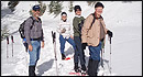 From alpine to desert, Outspire guides enrich your experience by giving context to your hike. So that your destination is not only what you see, but a sense of where the area fits in New Mexico's history, geology and natural world. Our hiking guides are experienced, enthusiastic, and motivated to share the joy of being outside! Day hikes and winter snowshoe outings are planned to suit your interests and fitness.
Helpful Links
Tour Companies
Outspire Hiking and Snowshoeing
- Santa Fe Area
- Snowshoeing, Hiking
- 505-660-0394
Details
Length:
Difficulty:
Time:
Trailhead Elevation:
Elevation Range:
Elevation Change:
Usage:
Season:
Useful Map(s):
Additional Details:
It is so close to town that a hike on the Chamisa can be completed in just a few hours. Also, the low elevation makes this ideal for the hiker with spring fever; it is clear of snow long before trails open up in the Pecos Wilderness and higher elevations.
Map + Directions
Basic Directions
Take State Road 475, also known as the Hyde Park Road, east from Santa Fe approximately 5 miles. About 1 mile beyond the Santa Fe National Forest entrance sign there is a small canyon with a small parking area on the left and a very large area for parking on the right side of the road. Chamisa trailhead is on the left or north side of the road.