


Contact Info
- Phone:
- 505-757-6121
Basics
- Length:
- 5 miles
- Difficulty:
- Difficult
- Time:
- 5 - 6 hours
- Trailhead Elevation:
- 9000 feet
- Elevation Range:
- 9000 feet to 11800 feet
- Elevation Change:
- 2800 feet
- Usage:
- Light to Moderate
- Season:
- Year Round
Description
From Walker Flats, the Middle Fork Trail starts by crossing the Rio la Casa. This first section of trail can be difficult to follow due to the many junctions with old logging roads. The trail goes down the riverbanks for a short distance and then curves away, contouring around the large ridge between the Rio la Casa and the Middle Fork. After arriving at the canyon created by the Middle Fork, the narrow trail starts a very steep, and rocky ascent with a sheer drop-off. Horsemen may prefer to lead their stock up this section of trail. After about two and-a-half miles, the trail leaves the river canyon, continuing to climb through forest and meadow to its end at the junction with North Fork Trail 269.
Tour Companies
Outspire Hiking and Snowshoeing
- Santa Fe Area
- Snowshoeing, Hiking
- 505-660-0394
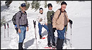 From alpine to desert, Outspire guides enrich your experience by giving context to your hike. So that your destination is not only what you see, but a sense of where the area fits in New Mexico's history, geology and natural world. Our hiking guides are experienced, enthusiastic, and motivated to share the joy of being outside! Day hikes and winter snowshoe outings are planned to suit your interests and fitness.
Helpful Links
Tour Companies
Outspire Hiking and Snowshoeing
- Santa Fe Area
- Snowshoeing, Hiking
- 505-660-0394
Details
Length:
Difficulty:
Time:
Trailhead Elevation:
Elevation Range:
Elevation Change:
Usage:
Season:
Useful Map(s):
Additional Details:
This trail is in the Pecos Wilderness. Motorized equipment and mechanized transportation, including mountain bikes, hunter carts, and chainsaws are prohibited.
Do not camp within 200 feet of the lakes or within 50 feet of a stream or trail. Use existing campsites and pack out all your trash.