


Basics
- Length:
- 119 miles (191 km)
- Time:
- 3 hours to drive the byway, or a day to visit
- Fees:
- Many of the State Parks and Visitors Centers have fees ranging from one to five dollars.
Description
Travel through history along the Western Trails Historic and ScenicByway. Drawn by the forgiving terrain and fertile land along the PlatteRiver, tens of thousands of the nation's pioneers traveled through thisvalley on their way West. The Oregon and Mormon Trails, the PonyExpress, stagecoaches and steam locomotives, outlaws and immigrants allfollowed, making this passage the Main Street of America in the 1800s.The byway, the present day Nebraska Highways 26 and 92, follows thishistoric route.
The trail begins in Ogallala, once known as the Gomorrah of thePlains, a rowdy city where cattle drives ended and "cuttin' loose"began. Some of the most colorful characters in western history passedthrough Ogallala, and many never left. You can visit some of these'tough guys' at the Boot Hill Cowboy Cemetery. Earlier travelersthrough the area are buried along this route at the Ash Hollow StateHistorical Park a few miles down the road. Home to the remains ofprehistoric rhinoceros, mammoths, and mastodons, and other ancientmammals that once roamed the Great Plains, Ash Hollow also shows thesigns of the more recent passing of immigrants whose wagon wheel rutsare etched in the plains.
Losing track of time is easy to do among the history of the WesternTrails Byway, but for some, Chimney Rock marked the end of travelingover the plains and the beginning of the Rockies. "Towering to theHeavens," as one early pioneer described it, Chimney Rock was the mostrecognized road sign along the trail west and one you could not miss.Another road sign along the trail west is Scott's Bluff. Rising 800feet above the valley floor, Scott's Bluff is named for a fur trapperwho died there in 1828, and is the site of many impressive geologicformations.
These sights were forever etched into the minds of the people whotraveled this area so many years ago, and after traveling in theirfootsteps along the Western Trails Scenic and Historic Byway, you willfind them forever within you as well.
Points of Interest
Points of Interest Along The Way
Agate Fossil Beds National Monument (NE)
The 3,000 acre Agate Fossil Beds is the home of 19.2 millionyear-old Miocene epoch mammal fossils. Like so many other fossilbeds, this area was once a watering hole, thus preserving a varietyof mammals. A life size fossil diorama depicts the life and deathof these animals. The park was once part of "Captain" James H.Cook's Agate Springs Ranch. This ranch was also a place where theOglala Lakota Indian people gathered. Among those was their chief,Red Cloud. On exhibit are many artifacts from the Sioux. There is awhetstone used by Crazy Horse, war club, a pipe used fornegotiations at Fort Laramie, and hide paintings.
Directions
NE
Ash Hollow State Historical Park (NE)
The Ash Hollow State Historical Park has been the site of humanoccupation for many years. Water, wood, fruits, and berriesattracted people to this area. Archaeological excavations show thatearly man used the area as much as 6,000 years ago. There is a rockshelter that was used by the Plains Indians. Later, pioneerstraveling over the Oregon Trail passed by this area, and itprovided much needed rest for the weary pioneers. Wagon ruts canstill be seen at the park today. Windlass Hill was one of the firstmajor hills that the pioneers had to cross. A one-mile hiking trailallows visitors to experience the many aspects of this park.
Directions
Lewellen, NE
Bald Eagle Viewing Center (NE)
Central Nebraska Public Power and Irrigation District's viewingfacility is located below Kingsley Dam/Lake McConaughy. The centeris open for eagle-viewing from late December to early March. LakeMcConaughy also provides the opportunity for year-round birdwatching. The variety of habitat at the reservoir and thesurrounding environs attracts one of the largest and most diversebird populations documented in the United States.
Directions
near Ogallala, NE
Boot Hill (NE)
Since cowboys generally were buried with their boots on, thefirst cemetery in the area was aptly named Boot Hill. It wasOgallala’s only official burying the "end of the trail"decade, from 1874 through 1884. A hundred or more people wererolled in canvas and dropped into a shallow grave during that time,a remarkable death rate for a settlement that never exceeded 130permanent residents. Among the bodies buried there is Union Pacifictracklayers killed in an Indian raid, horse thieves, and gun fightvictims. Also buried on Boot Hill were women and children who diedof consumption, snakebite, and typhoid.
Directions
Ogallala
Chimney Rock National Historic Site (NE)
"Towering to the heavens" is how one pioneer described Chimney Rock, the most recognized landmark along the Oregon Trail. Today an interpretive center operated by the Nebraska State Historical Society pays tribute to those who traveled the trails and features original maps made from Captain John C. Fremont's 1842-43 exploration of the Oregon Trail. This feature played a significant role in the westward migration because of its prominence as a landmark for those traveling west.
Directions
near Bayard, NE
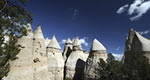
Court House and Jail Rocks (NE)
These two impressive rocks are unusual geological formations,which became landmarks along the Oregon and Mormon Trails. Thepioneers had many different names for these rock formations, andthey would often go out of their way to see these rocks. Theserocks are large, impressive rock formations that have been erodedand shaped by time and the elements. They are composed mainly ofBrule clay and Gering sandstone. These rocks are the easternmostextension of the Rocky Mountains, which Native Americans used forcamping and sending smoke signals.
Directions
near Bridgeport, NE
Crescent Lake National Wildlife Refuge (NE)
The Crescent Lake National Wildlife Refuge contains 45,000 acresof natural prairie and a number of small lakes that comprise thenesting and migratory bird refuge. Waterfowl and shorebirds use therefuge for nesting and feeding, and the refuge may be used forwaterfowl production. There are variety of different species ofwildlife at the refuge, such as raccoon, pronghorn, mule andwhitetail deer, and a variety of birds such as waterfowl,shorebirds, and songbirds.
Directions
NE
Front Street (NE)
Front Street is a replica front of some typical businesses toold western towns such as Ogallala, with a museum, saloon,restaurant, and gift shop inside. Evening entertainment during thesummer months begins with a shootout on the street followed by alively musical on stage in the Crystal Palace Saloon, featuringcowboys and dance hall girls.
Directions
Ogallala, NE
Lake McConaughy State Recreation Area (NE)
Lake McConaughy State Recreation is Nebraska's largestreservoir, earning the nickname "Big Mac." With nearly 36,000 acresof water and 5,500 acres of land, this recreation area has manyopportunities to enjoy the outdoors. There is both modern andprimitive camping, boating, surfing, water-skiing, swimming, andfishing. The walleye is the most prized of the fish that can becaught at Lake McConaughy, along with other game fish such asrainbow trout and channel catfish. There are miles of white sandybeaches for visitors to enjoy a relaxing day.
Directions
near Ogallala, NE
Lake Minatare State Recreation Area (NE)
Over 2,000 acres of water at Lake Minatare provide a variety offacilities for boaters, campers, fishermen and outdoor enthusiasts.Water skiing, fishing, boating, and swimming are a few of the mostpopular activities at the lake. The lake also has one of only seveninland lighthouses in America. This 55-foot stone structureprovides a unique look of the lake and the surrounding valley.Visitors can climb up the stairs to the top.
Directions
near Scottsbluff, NE