


Contact Info
- Phone:
- 505-757-6121
Basics
- Length:
- 14.5 miles
- Difficulty:
- Difficult
- Time:
- 9 - 10 hours
- Trailhead Elevation:
- 11200 feet
- Elevation Range:
- 11200 feet to 11800 feet
- Elevation Change:
- 600 feet
- Usage:
- Light
- Season:
- Year Round
Description
From the junction with Gascon Trail 239, the Skyline Trail continues south through a large grassland on the eastern divide. There is a cairned route along the east side of Cebolla Mountain as well as a trail on the west side. The most important thing is to continue south of the ridgeline. There is no visible tread in the grasslands. In many places the trail is obscure and there are multiple cairned or blazed routes. It is not necessary to cross the quartsize fields. Look for routes around them.
Approximately six miles south of the Gascon Trail junction is the junction with Rociada Trail 250. The trail maintains its southerly direction, alternating between forest and meadows. After two more miles, the trail intersects Los Esteros Trail 226 and after about five miles it intersects Porvenir Canyon Trail 247. The 1.5 miles of trail from here to Elk Mountain recieve much more use than the portions of trail to the north. The trail leaves the Pecos Wilderness just before arriving at Forest Road 646.
Tour Companies
Outspire Hiking and Snowshoeing
- Santa Fe Area
- Snowshoeing, Hiking
- 505-660-0394
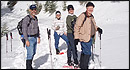 From alpine to desert, Outspire guides enrich your experience by giving context to your hike. So that your destination is not only what you see, but a sense of where the area fits in New Mexico's history, geology and natural world. Our hiking guides are experienced, enthusiastic, and motivated to share the joy of being outside! Day hikes and winter snowshoe outings are planned to suit your interests and fitness.
Helpful Links
Tour Companies
Outspire Hiking and Snowshoeing
- Santa Fe Area
- Snowshoeing, Hiking
- 505-660-0394
Details
Length:
Difficulty:
Time:
Trailhead Elevation:
Elevation Range:
Elevation Change:
Usage:
Season:
Useful Map(s):
Additional Details:
This trail is in the Pecos Wilderness. Motorized equipment and mechanized transportation, including mountain bikes, hunter carts, and chainsaws are prohibited.
Hikers and horsemen and horses must be in good physical condition and acclimated to high altitudes.