


Contact Info
- Phone:
- 505-757-6121
Basics
- Length:
- 4 miles
- Difficulty:
- Intermediate
- Time:
- 2.5 - 3.5 hours
- Trailhead Elevation:
- 10000 feet
- Elevation Range:
- 10000 feet to 11760 feet
- Elevation Change:
- 1760 feet
- Usage:
- Light to Moderate
- Season:
- Year Round
Description
This trail starts at an intersection with the Chimayosos Trail 246. Cross to the west side of the Rito de los Chimayosos. The trail then begins to climb immediately out of the canyon and follows along a ridge between the Rito Azul and the Rito de los Chimayosos. After about one and-a-half miles of climbing, the trail continues through forest and meadow for about two and-a-half miles and intersects Jack's Creek Trail 257 in a large meadow. The North Azul Trail continues northwest and climbs with an easier grade for another mile. The trails turns more to the north, traversing minor ridges fingering out from the main slope of the Truchas Peaks for another mile. The trail again climbs abruptly up the slope to emerge at a large boggy meadow, skrits the bog along the northwest side, and again climbs steeply up the hillside in the final ascent to the open areas at the junction with Skyline Trail 251, a quarter mile south of the lakes.
Tour Companies
Outspire Hiking and Snowshoeing
- Santa Fe Area
- Snowshoeing, Hiking
- 505-660-0394
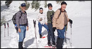 From alpine to desert, Outspire guides enrich your experience by giving context to your hike. So that your destination is not only what you see, but a sense of where the area fits in New Mexico's history, geology and natural world. Our hiking guides are experienced, enthusiastic, and motivated to share the joy of being outside! Day hikes and winter snowshoe outings are planned to suit your interests and fitness.
Helpful Links
Tour Companies
Outspire Hiking and Snowshoeing
- Santa Fe Area
- Snowshoeing, Hiking
- 505-660-0394
Details
Length:
Difficulty:
Time:
Trailhead Elevation:
Elevation Range:
Elevation Change:
Usage:
Season:
Useful Map(s):
Additional Details:
This trail allows users to make a loop, including the Iron Gate Road, for a half-day trip or to get to the Valle Largo Trail from Iron Gate without having to use the road.
This is the easiest and most direct route between Beatty''s Flats and Truchas Lakes.
Camping and campfires are prohibited 200 feet of lakes and within 50 feet of streams.
There are several good camping locations near the end of this trail below the Truchas Lakes.


