


Contact Info
- Phone:
- 505-757-6121
Basics
- Length:
- 11.5 miles
- Difficulty:
- Easy,
Intermediate,
Difficult - Time:
- 7 - 8 hours
- Trailhead Elevation:
- 8400 feet
- Elevation Range:
- 8400 feet to 11760 feet
- Elevation Change:
- 3360 feet
- Usage:
- Moderate to Heavy
- Season:
- Year Round
Description
The Gascon Trail is a long east-west trail that intersects most of the major north-south trails in this section of the Wilderness. The western portion is heavily used by hunters and by those going to Pecos Falls. The eastern portion is a major route for bringing cattle in and out of the Wilderness. At the western end, the Gascon Trail starts at a junction with Beatty's Trail 25 at a crossing of the Rito del Padre. The steep and eroded trail climbs up a grassy slope and then descends through forest to the junction with Pecos Trail 24. The two trails are the same for the next half mile, after which Gascon Trail continues eastward to the Pecos River and Pecos Falls. After the river crossing, the trail climbs first to the junction with Hamilton Mesa Trail 249 and then to the junction with Valdez Trail 224. After crossing the Rio Valdez, the trail climbs yet again toward the junction with Bordo del Medio Trail 252. The trail can be difficult to follow through a meadow before the trail junction but can be found by looking for the blazed trees where the trail re-enters the forest and heads strongly to the northeast.
The trail drops to the headwaters of the Mora in a wide grassy meadow and climbs up the east slope to the expansive grasslands at the top of the Eastern Divide. From here the Gascon Trail continues east across the divide to Gascon Point. The steep, rocky, narrow trail then drops 3,000 feet through private land to eventually terminate at the town of Gascon.
Tour Companies
Outspire Hiking and Snowshoeing
- Santa Fe Area
- Snowshoeing, Hiking
- 505-660-0394
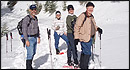 From alpine to desert, Outspire guides enrich your experience by giving context to your hike. So that your destination is not only what you see, but a sense of where the area fits in New Mexico's history, geology and natural world. Our hiking guides are experienced, enthusiastic, and motivated to share the joy of being outside! Day hikes and winter snowshoe outings are planned to suit your interests and fitness.
Helpful Links
Tour Companies
Outspire Hiking and Snowshoeing
- Santa Fe Area
- Snowshoeing, Hiking
- 505-660-0394
Details
Length:
Difficulty:
Intermediate
Difficult
Time:
Trailhead Elevation:
Elevation Range:
Elevation Change:
Usage:
Season:
Useful Map(s):
Additional Details:
This trail is in the Pecos Wilderness. Motorized equipment and mechanized transportation, including mountain bikes, hunter carts, and chainsaws are prohibited.
Use existing campsites and pack out all your trash.
From Gascon Point to the village of Gascon the trail lies on private land. Obtain permission before traveling on private land.


