


Contact Info
Pecos, NM 87552
- Phone:
- 505-757-6121
Basics
- Length:
- 3 miles
- Difficulty:
- Intermediate
- Time:
- 1.5 - 2.5 hours
- Trailhead Elevation:
- 8300 feet
- Elevation Range:
- 8300 feet to 9550 feet
- Elevation Change:
- 1250 feet
- Usage:
- Light
- Season:
- Year Round
Description
This trail climbs steadily at a moderate grade from Gallinas Canyon to Johnson Mesa. At the top, the trail ends at a junction with Na-na-ka Trail 217. A turn to the east will take you to Johnson Mesa. A turn to the west will take you to the Skyline Trail 251.
Tour Companies
Outspire Hiking and Snowshoeing
- Santa Fe Area
- Snowshoeing, Hiking
- 505-660-0394
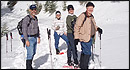 From alpine to desert, Outspire guides enrich your experience by giving context to your hike. So that your destination is not only what you see, but a sense of where the area fits in New Mexico's history, geology and natural world. Our hiking guides are experienced, enthusiastic, and motivated to share the joy of being outside! Day hikes and winter snowshoe outings are planned to suit your interests and fitness.
Helpful Links
Tour Companies
Outspire Hiking and Snowshoeing
- Santa Fe Area
- Snowshoeing, Hiking
- 505-660-0394
Details
Length:
3 miles
Difficulty:
Intermediate
Time:
1.5 - 2.5 hours
Trailhead Elevation:
8300
Elevation Range:
8300 feet to 9550
Elevation Change:
1250
Usage:
Light
Season:
Year Round
Useful Map(s):
USGS: El Porvenir
Additional Details:
If starting from Gallinas Canyon, park so as not to block access to the cabins located on the private land at the base of the trail.